Mon 02 September 2019:
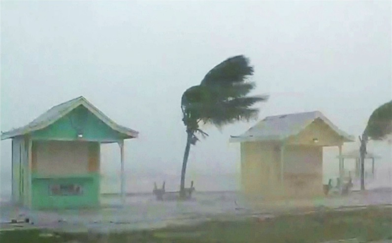
Massive waves, torrential rain and sustained winds of 285 kilometres per hour were reported as Dorian hit Elbow Cay in the Abaco Islands on Sunday at 12:40pm (16:40 GMT), the US National Hurricane Center (NHC) in Miami said.
The storm’s arrival poses a “life-threatening situation”, the NHC said.
The hurricane was the strongest recorded in modern history in the northwestern Bahamas, according to the National Weather Service. The NHC said it was tied for the strongest hurricane landfall in the Atlantic with the 1935 Labor Day Hurricane.
Residents reported power outages, flooding, roofs ripped off of buildings and the destruction of docks as the eyewall of the storm passed directly over the island. The property damage was “devastating”, said Joy Jibrily, director general of the Bahamas’ ministry of tourism and aviation, but no deaths had been reported by early evening on Sunday.
Footage coming from the #AbacoIslands shows some of the severe winds and rain coming from #HurricaneDorian pic.twitter.com/SB9vJLdbfy
— Met Office (@metoffice) September 1, 2019

The storm made its second landfall on the Great Abaco Island at 2pm (18:00 GMT) and was also expected to pass over Grand Bahama, the northernmost island in the country, later in the day as it moved west at a sluggish 11km/h.
Officials ordered residents to evacuate both areas, making several last-minute pleas as the storm made landfall.
“We cannot stress the amount of devastation and catastrophic impact that Hurricane Dorian is expected to bring,” Shavonne Moxey-Bonamy, the chief meteorologist ofBahamas, said on Sunday.
That devastation is expected to be prolonged as the hurricane stalls over the islands late on Sunday, leading to an extended period – potentially up to two days – of massive waves, flooding, power outages and rain.
The storm could cause sea levels to rise up to six metres and winds might reach a speed of 340km/h, according to the NHC.
The eye of #Dorian has made a second landfall at 2 pm EDT (1800 UTC) on Great Abaco Island near Marsh Harbour. Maximum sustained winds were 185 mph at the time. This is tied for the strongest Atlantic hurricane landfall on record with the 1935 Labor Day hurricane. pic.twitter.com/O9hrotTTbS
— National Hurricane Center (@NHC_Atlantic) September 1, 2019
One storm coming through from the far reaching outer bands of #Dorian and this wind is INSANE! @weatherchannel pic.twitter.com/QuABlDqxvl
— Tevin Wooten (@TevinWooten) September 2, 2019
Hurricane Dorian damage images are beginning to come out of Marsh Harbour in the Bahamas…these were shared by @Vernal0: pic.twitter.com/8RnniJqF4e
— Sean Breslin (@Sean_Breslin) September 1, 2019
“These hazards will cause extreme destruction in the affected areas and will continue for several hours,” the NHC said.
Many northern Bahamas residents hunkered down in schools, churches and other shelters as the storm approached.
But despite the orders to evacuate, officials said several residents had chosen to stay home to ride out the storm.
Silbert Mills, the 59-year-old owner of the Bahamas Christian Network, a local broadcasting company, told the Associated Press news agency he plans to ride out the storm on the Abaco Islands, where he said trees and power lines were already down and some roads had become impassable.
“The winds are howling like we’ve never, ever experienced before,” Mills said.
‘You have to evacuate’
In the northern stretches of the Bahamas archipelago, hotels closed, residents boarded up homes and officials hired boats to move people from low-lying areas to bigger islands as the hurricane approached.
Bahamas Prime Minister Hubert Minnis warned that Dorian is a “dangerous storm” and said those “who do not evacuate are placing themselves in extreme danger and can expect a catastrophic consequence”.
He added that 73,000 people and 21,000 homes were at risk from storm surges.
Approaching the US
The slow-crawling storm was predicted to take until Monday afternoon to pass over the Bahamas, and then turn sharply and skirt up the US coast, staying just off Florida and Georgia on Tuesday and Wednesday and then buffeting South Carolina and North Carolina on Thursday.
But the slow approach complicates the outlook for the US, National Hurricane Center Director Ken Graham told the AP, as the increased time allows small changes in the winds that steer the storm.
This means Dorian can still make landfall anywhere from Florida to North Carolina during the next five days, he said.
NOAA’s #GOESEast spotted lightning in the eye of #HurricaneDorian this morning. The now catastrophic Cat. 5 storm is expected to bring life-threatening storm surge and very heavy rainfall to the Abaco Islands and Grand Bahama through Monday. More: https://t.co/hGBv8RfDYM pic.twitter.com/dDxjoQjoJD
— NOAA Satellites (@NOAASatellites) September 1, 2019
Earlier in the week, US President Donald Trump, who cancelled a high-profile trip to Warsaw to focus on storm preparations, declared a federal state of emergency in Florida, authorising US assistance to supplement state and local efforts.
South Carolina and North Carolina have also declared statewide states of emergency, while Georgia announced a state of emergency for 12 counties.
Think your friends would be interested? Share this story!


