Wed 20 September 2023:
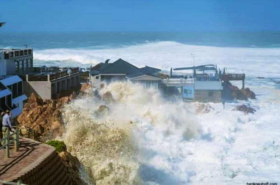
A series of powerful tidal surges battered coastal areas in South Africa’s Western Cape, Eastern Cape and KwaZulu-Natal provinces over the weekend of 16 September. One person died; cars, homes and businesses were damaged. The Conversation Africa asked Jasper Knight, a geoscientist who researches coastal processes, to explain what happened.
What drove the flooding?
A critical combination of three factors resulted in this significant flooding. First, a storm surge associated with low-pressure weather systems coming onshore. These happen very commonly but often don’t result in high amounts of flooding by themselves.
Second, low-pressure cells often result in strong onshore winds, and these can whip up the sea surface and create big waves which can potentially run further inland, especially when the sea surface is raised.
Third, the coincidence of the storm with the period of high tide (a monthly event) and equinoctial high-high tide (a seasonal event). It is this combination that is the cause here, not these individual factors in isolation.
What is a storm surge?
This is where the level of the sea surface near the coast is temporarily raised up and results in flooding along that coastal stretch. Storm surges are caused by a low pressure (cyclone) weather system approaching the coastline from the ocean. Low pressure causes the sea surface to bulge upwards below the centre or eye of the cyclone, and the magnitude of this disturbance is related to the severity of the low pressure system – the deeper the low pressure cell, the higher the elevation of the sea surface. This is usually on the order of tens of centimetres to one metre or so.
As the cyclone approaches land, the water surface along the coast rises.
What is a spring tide?
Despite their name, spring tides are regular occurrences throughout the year. They take place when the sun, Earth and moon are in alignment, and this happens once every (lunar) month. In addition, there are also times of the year, around the equinoxes, where spring tides are higher than average.
We are very near the spring (vernal) equinox in the southern hemisphere (which is on or about 22 September). This is a period when the sun is aligned overhead of Earth’s equator and so exerts a bigger tidal force on the oceans. This may have been a contributing factor to the higher water levels around the coast.
Were people sufficiently warned?
Tidal patterns are highly predictable and this data is widely available for ports or harbours along the coast. In this case, the South African Weather Service issued a warning. This information is particularly useful for boaters, fishermen and other coastal users. Weather patterns are also fairly predictable, which is what weather forecasting is all about, so we know when a big storm may be approaching.
However, the net result of all of these factors in combination is less predictable: although low-lying coastal areas are vulnerable to flooding, forecasters may not know exactly when or how high.
Storm Surge 16/17 Sept – What happened & why?
🌊Waves up to 9.5m affected >50% of the SA coast.
>causing damage to buildings, swept away vehicles, beach erosion, multiple injuries & 2 deaths.Gales, high swells & spring tide occurred at the same time.
⚠️No alerts today and tmw pic.twitter.com/Jp9qqcGJSN— SA Weather Service (@SAWeatherServic) September 18, 2023
The other issue here is not just areas being covered by water but also the speed at which the water waves are moving, which is a factor in their destructiveness.
What kind of emergency measures could be put in place?
Local communities need to be warned more clearly and effectively if there is a threat of a storm surge and of coastal flooding. People and assets (like cars, anything that is moveable) should be moved from the area or kept inside. People tend to want to go to the sea to watch the waves but this puts them at more risk. Roads should be closed off where possible to keep people safe and away from the area. Floodwater management through using sandbags and similar actions should be undertaken.
Exactly the same measures used in places like Florida in the US for reducing hurricane risk should be used in South Africa, such as boarding up windows, keeping assets indoors, evacuating people from high risk areas, and moving furniture in houses to the first floor to reduce flood impacts.
Author:
![]()
Jasper Knight
Professor of Physical Geography, University of the Witwatersrand
I am a geoscientist with research interests in the spatial and temporal variability in morphosedimentary system responses to rapid hemispheric-scale climatic and environmental changes during the late Pleistocene and Holocene. I focus thematically on glaciers, coasts and mountains and their responses to past, present and future climate change. I focus geographically on the UK and Ireland, northwest USA, Australia, European Alps, New Zealand, Spain and in southern Africa too. I supervise a number of graduate students on a range of pure and applied topics.
______________________________________________________________
FOLLOW INDEPENDENT PRESS:
TWITTER (CLICK HERE)
https://twitter.com/IpIndependent
FACEBOOK (CLICK HERE)
https://web.facebook.com/ipindependent
Think your friends would be interested? Share this story!


