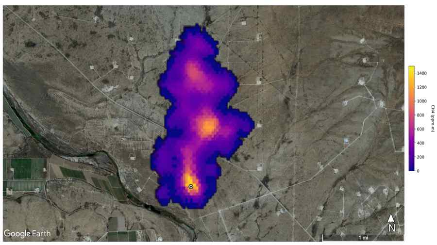
![]() NASA’s Earth Surface Mineral Dust Source Investigation mission detected southeast of Carlsbad, New Mexico. Methane is a potent greenhouse gas that is much more effective at trapping heat in the atmosphere than carbon dioxide. Credit: NASA/JPL-Caltech-FILE PHOTO
NASA’s Earth Surface Mineral Dust Source Investigation mission detected southeast of Carlsbad, New Mexico. Methane is a potent greenhouse gas that is much more effective at trapping heat in the atmosphere than carbon dioxide. Credit: NASA/JPL-Caltech-FILE PHOTO
Thu 15 February 2024:
Google and the nonprofit Environmental Defense Fund (EDF) have partnered to map oil and gas infrastructure and methane emissions from space.
MethaneSAT, a satellite owned by the Environmental Defense Fund, is scheduled to launch in the near future to gather satellite data.
The tech giant stated in a statement that this data, along with Google’s AI and infrastructure mapping, will improve understanding of how to reduce methane emissions.
The last ten years have been the hottest since 1850, with 2023 being the hottest year ever recorded.
Methane from human sources is responsible for about 30 per cent of global warming today, and a big contributor of methane in the atmosphere comes from extracting fossil fuels, like oil and gas, from the Earth.
By powering methane detection algorithms with Cloud computing and applying AI to satellite imagery to identify oil and gas infrastructure around the world, the goal is to help EDF quantify and trace methane emissions to their source.
“We are announcing a partnership with EDF that combines our science and technology to reduce methane emissions. This is one of the most powerful, short-term actions we can take to reduce warming,” said Yael Maguire, VP and General Manager, Geo Developer & Sustainability, Google.
“With this information, energy companies, researchers and the public sector can take action to reduce emissions from oil and gas infrastructure faster and more effectively,” said Google.
MethaneSAT will launch on a SpaceX Falcon 9 rocket in early March and circle the planet fifteen times a day at a height of more than 350 miles.
The levels of methane in the world’s most productive oil and gas locations will be measured for routine study.
Later this year, the insights will be made available to researchers and organizations via Google Earth Engine and on the MethaneSAT website.
SOURCE: INDEPENDENT PRESS AND NEWS AGENCIES
______________________________________________________________
FOLLOW INDEPENDENT PRESS:
WhatsApp CHANNEL
https://whatsapp.com/channel/0029VaAtNxX8fewmiFmN7N22
![]()
TWITTER (CLICK HERE)
https://twitter.com/IpIndependent
![]()
FACEBOOK (CLICK HERE)
https://web.facebook.com/ipindependent
![]()
Think your friends would be interested? Share this story!