
Fri 22 September 2023:
South Africans across the country should brace themselves for a four-day period of severe weather as a cut-off low pressure system forms over the west coast, according to the South African Weather Service (Saws).
Saws added that the system is predicted to form on Saturday evening and quell by next Tuesday.
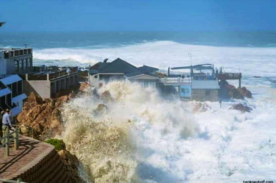
South Africans may experience another significant storm system over the weekend and early next week following the damaging coastal storm surge and wind events of the past week.
A cut-off low-pressure system (the equatorward displacement of a low-pressure system at high altitudes) is expected to develop along the west coast of South Africa from Saturday night (23 September). Cut-off lows are notorious for causing widespread severe weather such as flooding, heavy rainfall, and severe thunderstorms. Widespread showers and thundershowers can be expected across western, central, and southern South Africa, particularly from Sunday onwards.
However, notable uncertainty exists regarding the position and spatial distribution of the cut-off low at this current time, and further analysis will be required. Subsequent media releases will be issued leading up to the event.
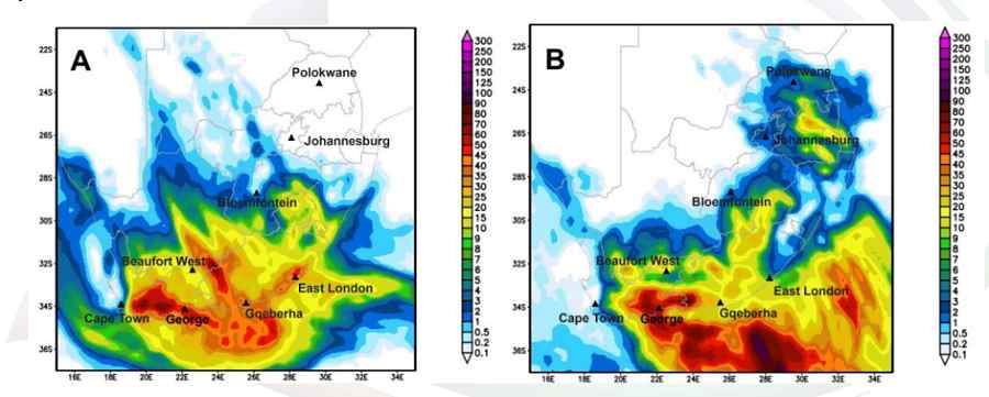
Figure 1: Numerical weather prediction data indicating 24-hour accumulated rainfall for A) Sunday (24 September) and B) Monday (25 September). (Source: Global Forecast System, NCEP)
A cut-off low will develop along the country’s west coast on Saturday evening after the passage of a weak cold front. Light rain can be expected along the Garden Route of the Western Cape as well as the coast and adjacent interior of the Eastern Cape on Saturday. Isolated to scattered thundershowers will develop from the afternoon over the interior, extending from the eastern parts of the Northern Cape to the western Free State and later the interior of the Eastern Cape.
The cut-off low will rapidly intensify by Sunday as it gets displaced northwards. It is expected to enter the country’s western interior, where it will result in widespread thundershowers and rain over parts of the Western Cape, Northern Cape, Eastern Cape, and southern Free State (Figure 1).
The Western Cape, Northern Cape, and western areas of the Eastern Cape may experience severe thunderstorms where bursts of intense rainfall may cause flash flooding. Strong to gale-force winds and very rough seas of 4,0 to 6,0 m are expected along the coastal areas, particularly along the Western Cape and Eastern Cape coast on Sunday and Monday. It will also be very windy over the central and eastern interior of the country from
Sunday into Monday, and the combination of the warmer and windy weather could increase the risk of veld fires in open areas. Cold conditions can be expected over the western and southern parts of the country from Sunday (Figure 2), including the central parts on Monday, but it will be very cold in places over the southern interior with a possibility of light snowfall over the north-eastern high-lying areas of the Eastern Cape and Lesotho on Monday. It will still be hot over the northern and north-eastern provinces, and even very hot in the lowveld areas of Mpumalanga and Limpopo.
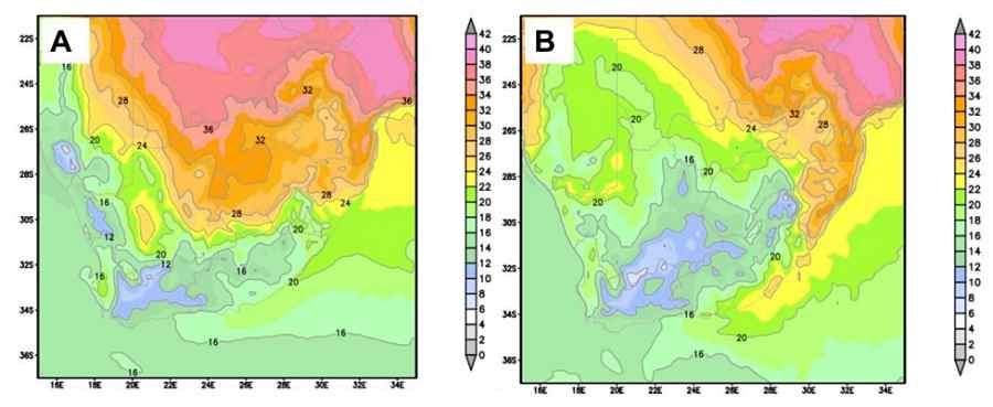
Figure 2: Numerical weather prediction data indicating the predicted maximum temperatures for A) Sunday (24 September) and B) Monday (25 September). (Source: Global Forecast System, NCEP)
On Monday, the cut-off low will move to the southern coast, developing a so-called scorpion’s tail (a deep low-pressure at the surface that is steered by stronger winds high up in the atmosphere and contains convective clouds), which will bring about further widespread and heavy rainfall over the southern parts of the Western Cape and the southern parts of the Eastern Cape, where current numerical model data suggests 24-hour rainfall amounts in the order of 60-100 mm along the coastal towns and mountainous areas of the Garden Route. On Monday, the Eastern Cape’s coastal areas and the Western Cape’s south coast will experience continued gale-force winds. The cut-off low is expected to move away from the country on Tuesday.
The South African Weather Service will continue to monitor this weather system and issue subsequent updates over the next few days. Updated impact-based warnings will be issued in due course. It is strongly advised that the public regularly follow weather forecasts on television, radio, as well as all social media platforms. Updated information in this regard will regularly be available at www.weathersa.co.za as well as on Twitter @SAWeatherServic and Facebook @SouthAfricanWeatherServic.
SOURCE: INDEPENDENT PRESS AND NEWS AGENCIES
______________________________________________________________
FOLLOW INDEPENDENT PRESS:
TWITTER (CLICK HERE)
https://twitter.com/IpIndependent
![]()
FACEBOOK (CLICK HERE)
https://web.facebook.com/ipindependent
![]()
Think your friends would be interested? Share this story!